


Természetjáró, a túratervező
Deskripsi Természetjáró, a túratervező
Pemandu wisata online Hongaria, yang dikembangkan khusus untuk pejalan kaki, pengendara sepeda motor, pelari trail, pemanjat tebing, dan pecinta olahraga air, menampilkan perencana tur bawaan, serta ratusan tur yang direkomendasikan dan ribuan pemandangan, semuanya dengan deskripsi terperinci dan banyak foto , dapat dilihat dengan nyaman di peta interaktif. Tersedia secara gratis, dengan opsi berlangganan untuk fungsionalitas yang diperluas.
Fitur
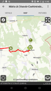
• Berbagai peta pendakian seluruh dunia yang interaktif, dapat diperbesar, dan divektorkan dengan semua jalur yang ditandai, menunjukkan posisi Anda saat ini
• Cara mudah untuk merencanakan tur Anda sendiri di peta, dan segera mendapatkan profil panjang, durasi, dan ketinggian
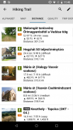
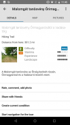
• Lebih dari seribu tur yang direkomendasikan untuk pejalan kaki, pengendara sepeda motor, pelari trail, dan kano, dengan data praktis, penjelasan mendetail tentang pemandangan terbaik di sekitar, latar belakang alam dan budaya, foto berkualitas baik, dan informasi tentang cara menuju ke sana
• Ribuan pemandangan yang direkomendasikan di Hongaria, termasuk menara observasi, titik panorama alam, kereta hutan, benteng, dan museum, dengan penjelasan mendetail, foto berkualitas baik, ditambah informasi tentang cara menuju ke sana
• Ratusan akomodasi, termasuk pondok, hotel dan apartemen wisata, dekat jalan setapak yang ditandai
• Koleksi berguna dengan tampilan peta: pantai di sekitar danau Balaton, arena seluncur es, kebun raya, rute lari terbaik, tempat panjat tebing, tur untuk penyandang disabilitas, dll.
• Pemberitahuan, peringatan dan penutupan
• Unduh bagian peta, tur, dan pemandangan untuk penggunaan offline
• navigasi sambil berjalan di sepanjang rute dengan profil ketinggian langsung dan instruksi suara
• Rekam rute Anda
• BuddyBeacon: bagikan posisi Anda dengan teman secara langsung
• Hungarian Blue Tour yang lengkap, dengan bagian dan rute resmi, POI, dan akomodasi
• Sinkronkan semua konten Anda antara komputer dan perangkat seluler yang menjalankan aplikasi
• Periksa ramalan cuaca setempat
• Penerbangan 3D: pemandangan tur secara virtual
• Alat bawaan yang berguna, seperti pencari puncak(Skyline) dan kompas dengan posisi Anda saat ini
• Layanan komunitas: memberi peringkat dan berbagi konten dengan teman-teman Anda
Jam tangan pintar dengan WEAR OS dari Google
Dengan melihat sekilas jam tangan pintar Anda, Anda mendapatkan informasi tentang posisi GPS Anda di peta. Anda dapat merekam trek, mendapatkan data pelacakan, dan bernavigasi di sepanjang rute. Gunakan ubin aplikasi untuk mengakses rute terdekat dengan mudah.
Khusus untuk anggota Pro
Pergi ke mana pun : Outdooractive Pro bekerja offline tanpa sinyal seluler dan data. Daftar tak terbatas juga dapat dibuat dan aplikasinya bebas iklan. Selain itu, Anda dapat melihat citra satelit, peta Outdooractive unik dengan lebih dari 30 jaringan jalur aktivitas dan peta topografi resmi dari penyedia berikut:
Survei Persenjataan Inggris Raya, Landranger, Explorer
Informasi Tanah Selandia Baru
Utah USGS
BKG Jerman
Austria BEV
Swiss swisstopo
Perancis IGN
Spanyol CNIG
Italia
PDOK Belanda
Norwegia Kartverket
Denmark Kortforsyningen
Swedia Lantmäteriet
Survei Tanah Nasional Finlandia
GSI Jepang
Peta Global
Khusus untuk anggota Pro+
Pro+ juga berisi peta resmi dari Alpine Associations serta peta premium dari KOMPASS.
Jika Anda memiliki pertanyaan atau saran, silakan kunjungi
https://www.termeszetjaro.hu/hu/p/gyakran-ismetelt-kerdesek/41050512 /
Versi desktop kami:
https://www.termeszetjaro.hu/
Ikuti kami di Facebook:
https://www.facebook.com/Termeszetjaro.hu/
Hubungi kami:
termeszetjaro@termeszetjaro.hu
Lebih lanjut tentang kartu TEKA:
http://www.termeszetjarokartya.hu/
Természetjáró, a túratervező - Informasi APK
Versi APK: 3.20.3Paket: com.outdooractive.mtszVersi Terakhir dari Természetjáró, a túratervező
Versi lain


Aplikasi pada kategori yang sama

Anda juga mungkin suka...
Aplikasi pada kategori yang sama


